
Taking Side-Scan to New Heights: SPH Engineering’s EchoNIMBUS-SSS
Side-scan sonar has long been one of the most powerful tools for underwater detection and seabed mapping - but traditional deployment methods have always come with limitations. Survey vessels are expensive, slow to mobilise, and often struggle to access shallow or difficult-to-reach water bodies. SPH Engineering is changing that with the EchoNIMBUS-SSS, a drone-mounted side-scan sonar payload that brings this powerful technology to the skies.
A recent live webinar hosted by SPH Engineering gave viewers a detailed look at how drone-mounted side-scan sonar (SSS) works, how it differs from other acoustic survey methods, and what real-world survey data actually looks like. If you missed it, the recording is well worth watching - and this blog covers the highlights.
What is Side-Scan Sonar - and how does it differ from other methods?
The webinar opened by breaking down the key differences between three main types of acoustic survey technology: single-beam echo sounders (SBES), multibeam echo sounders (MBES), and side-scan sonar (SSS). While SBES measures water depth directly below a sensor and MBES creates a wide swath of depth data, SSS works differently - it emits acoustic pulses out to either side, building up a detailed acoustic image of the seafloor rather than a depth profile.
This makes SSS particularly effective for detecting and identifying objects, structures, and features on the seabed, rather than simply measuring its depth. Think shipwrecks, pipelines, debris fields, or seabed texture changes - SSS excels where visual clarity of the bottom is the priority.
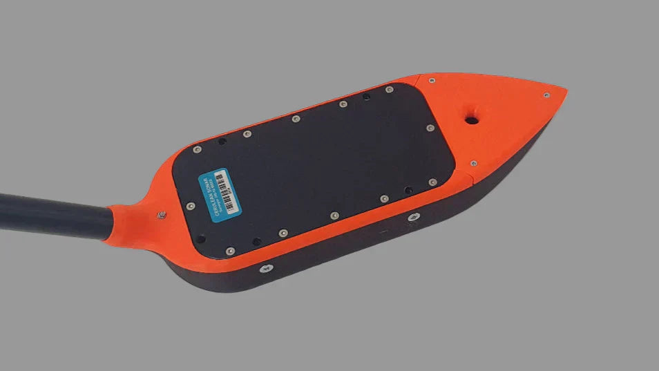
Introducing the EchoNIMBUS-SSS Payload
The EchoNIMBUS-SSS is SPH Engineering’s drone-integrated side-scan sonar solution, built around the Cerulean Omniscan 450SS - a high-performance, professional-grade sonar sensor. The complete payload includes:
-
2x Cerulean Omniscan 450SS side-scan sonar transducers
-
Foldable mount and electronics housing
-
Ethernet switch module
-
Explorer transport case for easy field deployment
The Omniscan 450SS operates at 450 kHz and delivers impressive technical performance. With a measurement range of up to 150 metres per side and an exceptionally narrow along-track beam width of just 0.5 degrees, it produces high-resolution imagery with fine along-track detail. Cross-track resolution is user configurable up to 1/1200th of the range setting, giving significant control over image quality depending on the survey requirements.
The dual-transducer configuration means both port and starboard sides of the flightpath are covered simultaneously, maximising efficiency and coverage in single pass. The total payload weight is 1.8kg for the sonar system, or 2.4kg including the SkyHub onboard computer and associated hardware - well within the payload capacity of supported drones including the DJI M400, M350 RTK, and M300 RTK.
Why Drone-Mounted? The Real Advantages
The webinar made a compelling case for why mounting side-scan sonar on a drone - rather than a vessel or ROV - opens up entirely new possibilities for survey teams:
-
Faster deployment: No need for a boat, crew, or a trailer, A drone can be in the air and collecting data within minutes of arriving on site.
-
Improved accessibility: Shallow water, rivers, flooded areas, and environmentally sensitive sites that vessels simply cannot access become surveyable.
-
Reduced cost and risk: Fewer personnel and no marine vessels means lower operational costs and reduced safety risks in challenging environments.
-
Efficient shallow-water surveys: Drone-mounted SSS is particularly well-suited to water bodies where traditional deployment is impractical.
Applications Across Multiple Sectors
The EchoNIMBUS-SSS is designed for a wide range of professional applications, including:
-
Search and recovery operations
-
Seabed and lakebed mapping
-
Locating underwater hazards such as shipwrecks and buried pipelines
-
Archaeological surveys of submerged sites
-
Environmental monitoring and habitat assessment
Real Data, Real Results
One of the most valuable parts of the webinar was the presentation of real survey data gathered using the EchoNIMBUS - SSS. Attendees were walked through examples of what SSS imagery looks like in practice, how to interpret acoustic returns, and what kinds of features can be reliably detected. SPH Engineering has also made a sample dataset from Titurga Lake available for download, allowing prospective users to explore the data quality for themselves before committing to a system.
Watch the Webinar and Find Out More
The full webinar recording is available on YouTube - a must-watch for anyone involved in hydrographic survey, underwater search, environmental monitoring, or drone integration
Share:
L1 pool cleaner
Sytis Case Study