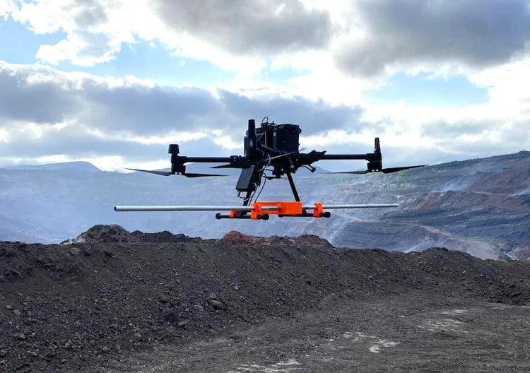
Ground Penetrating Radar (GPR) uses radar pulses to detect and image underground objects and features. A GPR transmitter emits electromagnetic energy into the ground. When the energy encounters a buried object or a boundary between materials having different dielectric permittivities (a property that defines the speed of electromagnetic waves), it may be reflected to the receiving antenna of GPR. The GPR electronics can then record the variations in the return signal.

Fig.1 - Drone-Mounted GPR Detecting Underground Anomalies
Deliverables
GPR data comes from the sensor in digital form and is not meant for direct human interpretation, unlike photos from cameras. It requires specialized software for processing and interpretation.
These methods of GPR data representation are the most popular, but many additional options exist, including export into formats that can be imported into CAD and GIS systems.

Fig.2 - GPR profile crossing a gas pipeline with interpretation. Data was collected using the Zond Aero 500 GPR system, processed, and interpreted in Radar Systems Prism2 software
The results of GPR surveys can be presented in different forms. The most common and “natural” format for GPR data is a “profile” - a vertical slice of data along the survey line.

Fig.3 - Horizontal slice of the subsurface to visualize the path of utilities. Data was collected using the Zond Aero 500 GPR system and processed in Geolitix
Another popular form is horizontal slices, as they give a better understanding of where the detected objects are under the surface and about the shape of objects.

Fig.4 - 3D representation of the same utilities as on the image with horizontal slices. Screenshot of Geolitix
Many customers prefer to see 3D reconstructions of the underground world - and that is also possible. It will require more processing and preparation steps, but as this method gives maximum understanding in complex situations, it becomes more and more popular, thanks to modern GPR processing software radically simplifying that task.

Fig.5 - Ice thickness grid. Data was collected using the Zond Aero 1000 GPR system and processed in Geolitix
One more popular method is to generate thickness grids, for example, to answer questions like “How thick is the sand layer covering bedrock” or “How thick is the ice”.
Benefits of drone-mounted GPR
Drone-mounted GPR implements the motto “safer, cheaper, faster.” Here are a few situations where the use of GPR on the drone is beneficial
- Rough terrain where surface surveys may be impossible (ice and snow-covered ground, rocky and uneven terrain, across rivers and in avalanche-prone areas)
- Areas with safety or health risks for the operator (glaciers with crevices, contaminated soils, etc.)
- Large unobstructed areas where the productivity of terrestrial surveys will not be economically reasonable (for example, scanning huge fields for solar panel farms for the depth of bedrock and presence of rocks)

Fig.6 - A drone with Zond Aero LF GPR is taking off to scan the dangerous site with coal burning underground. The picture courtesy of DATUM Ingeniería SAS.
Why do we need different GPR systems?
All GPR systems use the same principles but vary in application due to different antenna frequencies:
- Low-frequency GPR systems penetrate deeper with lower resolution and are suitable for larger objects at greater depths.
- High-frequency GPR systems offer higher resolution for smaller objects but have limited penetration.
The antenna design reflects:
- Low-frequency antennas are larger and unshielded
- High-frequency antennas are compact and shielded to reduce noise.
The variety of GPR's ensures the right system for every subsurface investigation needs.


Share:
Exploring the Depths using Cerulean Sonar USBL with Chasing ROV
Most affordable forward imaging solution for ROVs