
Shipwreck Discovery off the Coast of Madura Island, Indonesia
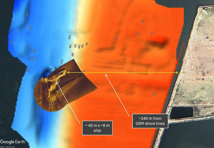
During a bathymetric survey in the coastal waters of Madura Island, East Java, Indonesia, we discovered a previously undocumented shipwreck measuring approximately 40 x 8 meters. The discovery was made around 240 meters offshore, directly in front of our survey base.
Survey Equipment & Setup
Our unmanned surface vehicle (USV), the BlueBoat, was equipped with:
Cerulean Surveyor 240 Multibeam Echo Sounder (MBES)
Twin Omniscan 450 Side Scan Sonars (SSS)
This setup enabled us to capture both high-resolution bathymetric data and detailed side-scan imagery.

Day 1: Initial Discovery – May 29, 2025
At the end of the first survey day, we reviewed SVLOG files from the Surveyor 240 MBES using SonarView software. A distinctive structure resembling a shipwreck was visible in the point cloud data.
To validate the structure, we processed the MBES point cloud using CloudCompare for dimensional analysis and geolocation. The estimated size was ~40 meters in length and ~8 meters in beam. The combined point cloud was imported into ReefMaster, where we marked the wreck location and merged the new dataset with a previous single-beam echo sounder (Ping2 SBES) dataset from May 2024.

Day 2: Visual Confirmation with Side Scan – May 30, 2025
On the second day, we navigated the BlueBoat back to the wreck site and deployed both Omniscan 450 side scan sonars. By running multiple passes, we generated a clear sonar mosaic that visually confirmed the presence of a shipwreck.

Technology Enablers
The extended survey range — 370 meters offshore, compared to 200 meters in 2024 — was made possible by upgrading the BlueBoat with:
4G LTE connectivity
Zerotier for remote operations and control
Without the MBES, the shipwreck would have likely gone undetected. This discovery was made possible by the synergy of multibeam and side scan technologies, strategic planning, and a bit of good luck.

Takeaways
MBES is essential for detecting structural anomalies like wrecks in seafloor surveys.
Side Scan Sonar provides critical visual validation post-discovery.
4G-enabled USVs significantly extend operational range and data reliability in coastal environments.
This find underscores the value of high-resolution acoustic mapping systems and the potential for autonomous platforms to uncover submerged heritage and unknown features.

